

Global Coverage
We’re always working hard to bring new regions like France, Spain, Brazil, US, Australia, Germany and 30+ more.

Historical Data
We provide our models with agri data historically (back to 2016) and in-season including seeded acres.

Predictable Price
We've prepared a convenient system of discounts for increasing the volume of use. More requests - less price.

CEO is a Farmer
15th generation farmer from Norway, passionate about sustainable agriculture and farming heritage.

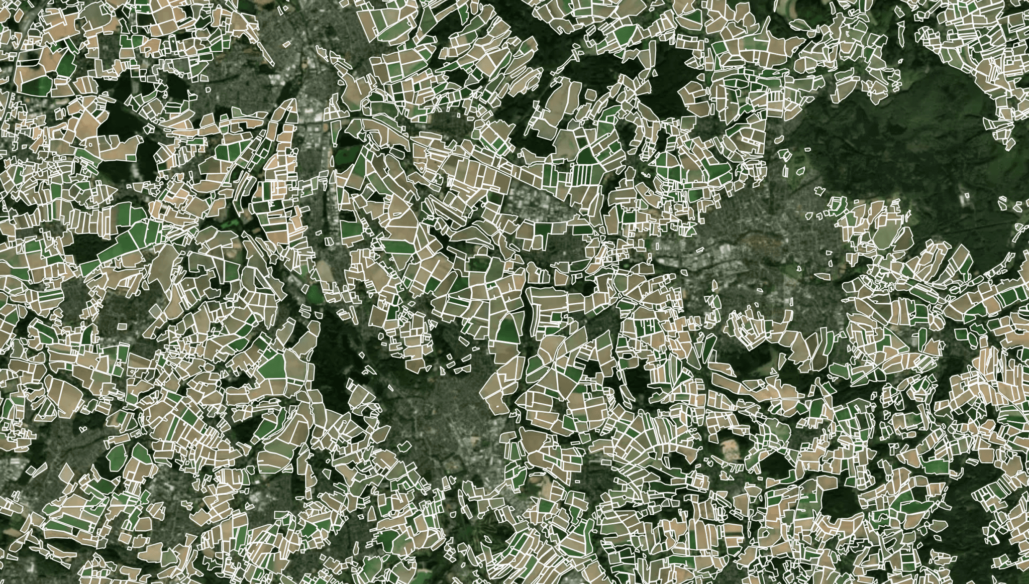
Every Precision Agriculture Service Starts With Accurate Field Boundaries
We have a state-of-the-art deep neural network model for Field Delineation (Automatic Detection of Field Boundaries and Seeded Acres) with 10x higher resolution than existing Sentinel-2 at 10m based models.
“It’s imperative that technology providers with aligning missions work together to provide agricultural organizations with the data and tools they need to improve sustainability across their supply chains.”
Descartes Labs
Technical Partner
Analyse Field Performance With Machine Learning Models
We spent a lot of time perfecting our boundaries and seeded acres agri data which is the basis for all precision ag-services and in-field analytics. We provide agtech API solutions so you can easily plug-and-play with the data you're looking for.


Limitless Possibilities Of Satellite Images
We developed a neural network model that enhances the spatial resolution of Sentinel-2 from 10 meters to 1 meter per pixel, both atmospherically and radiometrically calibrated.
“The imaging data enables the reconstruction of spatial features and textures not visible on the original Sentinel-2 data.”
Konstantin Varik
Co-Founder and CTO
Daily Satellite Data Analytics
Policy & Paying Agencies (CAP, LPIS, IACS)
Support evidence-based policy implementation through continuous CAP compliance monitoring.
Crop-type mapping for compliance checks
Automated parcel verification and control
Yield analysis for policy performance monitoring
Detection of land-use change and eligibility verification
Insurance
DigiFarm delivers high-resolution, satellite-based intelligence to reduce costs, delays, and uncertainty.
Automated parcel identification during claims
Crop-type and yield verification for policy validation
Damage detection after extreme weather events
Portfolio risk monitoring across regions
Agriculture
DigiFarm’s helps agricultural players increase efficiency, reduce costs, and make data-driven decisions.
Precision field mapping and management zones
Crop identification and seasonal monitoring
Precision spraying and planting
Farm digitalization and advisory tools
Yield forecasting and performance benchmarking
Compliance (Global Monitoring & Verification)
Ensure transparency and traceability with AI-powered global monitoring and field-level verification at scale.
Land-use change and deforestation monitoring
Verification of crop origin and sourcing compliance
Traceability and reporting for sustainability standards
Continuous monitoring of regenerative practices
Ship and vessel activity detection

We also develop custom projects in similar areas. Contact us to discuss your needs.


Unlocked Demo Areas
Multiple regions to test our Agtech solutions. To open a new region you need to make a token request.
Full Usage Control
You start with free requests and setup all the limits and subscription options according your product capacity.
Clear Documentation
We provide full access to all our documentation and simple API / Add-ons endpoints for easy integration.
Achievements And Recognitions
We do an excellent job by delivering accurate models and Agtech solutions for our customers, understanding their needs and helping to evolve the industry as a whole.


Reviews From Our Clients And Partners
Helping our clients and partners build a sustainable future for food and agriculture.


